Exploring the Interaction Between Urban Freight and Land Use.
Exploring the Interaction Between Urban Freight and Land Use.
Part 1: Outdoor Space
Authored by: Lukas Marthaler & Lorena Axinte
The interaction between transport and land use is complex and dynamic, both spatially and temporally. Any modifications to land use can determine changes in movement patterns, both for the transport of people and for the transport of goods. For instance, unlocking a green field for a new residential area will potentially require new roads, and will surely induce new journeys (including for logistics purposes). Similarly, the development of transport infrastructure between two points can lead to new developments along the route, be they residential, industrial, or mixed-use, creating self-reinforcing dependencies between transport and land use.
In this insight series we explore the specific interactions between urban freight transport (UFT) and land use, for both outdoor and indoor spaces. Looking at the most recent disruptions, we identify the challenges for urban planning & dynamic space management, and for the logistics sector. Finally, we highlight some of the solutions developed to tackle these challenges, from tools to better understand interactions, to policies for optimizing space management, as well as technologies and vehicles better adapted to new urban conditions.
Seven Challenges at the Intersection of Freight and Land Use
The relationship between freight and land use is constantly changing, being influenced by a variety of factors such as zoning, policies and access regulations, land price, transport accessibility, market demand, technological development, and consumer preferences. Logistics are essential for any community to thrive, but they also amplify urban issues such as congestion and pollution. In the past two years, the freight sector has become much more visible in urban areas, determining local authorities to intervene and minimise its negative externalities (Local Government Association, 2022). Nonetheless, various challenging factors remain:
1. Many unknowns regarding the spatial footprint of Urban Freight Transport
UFT’s spatial footprint is hard to estimate, and to our knowledge, this is a gap in the current understanding of most local authorities1. Such an estimate would need to consider the amount of space required to support freight infrastructures (roads, parking, loading and unloading areas, etc.), as well as spaces for replenishment and consolidation (terminals and hubs). Many of these elements are not solely used for freight (e.g., roads are shared with other users, manufacturing sites might include logistics activities), adding to the complexity of such calculations.
Despite the lack of a baseline to quantify UFT’s entire spatial footprint, urban areas have seen the intensification of last mile deliveries, induced by the COVID-19 pandemic, the increased digitalization of commerce and the on-demand economy. This has led to certain substitutions that are yet to be tracked and understood. For instance, the substitutions between direct shopping vs. e-commerce deliveries, the change between different types of vehicles such as smaller vehicles for food deliveries vs. own car for pickup/shopping, or the origin-destination of journeys, are all unknowns. Although the impact on space and emissions depends on initial circumstances and resulting changes, some implications for land use can be delineated.
2. Varying and changing needs for the logistics sector
Segmentation within logistics is very high, adding to the complexity of the question. Retail, parcel & post, agri-food & HORECA, services (e.g., maintenance, B2B laundry for hotels, etc.), construction & industrial operations, and waste will all have different travel patterns and drop densities. For some sectors (e.g., parcel and post), small and electric vehicles might already be the norm, whereas for others (e.g., waste management, utilities), decarbonisation might still take a long time.
Traditionally, zoning used to focus on a clear separation of land uses, setting boundaries between potentially incompatible activities such as housing and manufacturing. E-commerce and various urban vehicle access regulations are blurring these lines, highlighting the necessity of proximity between replenishment spaces (be they consolidation centres, micro-hubs, or HORECA establishments) and delivery destinations. For smaller, alternatively fuelled vehicles to replace fossil-fuelled vans, logistics hubs must be located closer to the city centres or residential neighbourhoods. This adds another layer of pressure to the scarce resource of urban space, for which various uses are already competing. More flexible regulations are needed to facilitate clean last mile deliveries, but the suitable configuration remains a question. Inner city hubs have implications for traffic and potentially for the vitality of local commerce, too. The second article in this series will further explore this topic.
3. Growing needs of public space, parking and kerb use
Besides the need for replenishment and consolidation space within city boundaries, the logistics sector has increasing requirements for parking, loading and unloading areas. Some estimates claim that while parking demand used to be around 95% private (Schaefer, 2021), since 2020, commercial vehicles might make up around 30% of the parking activity (Davani, 2020). This trend is expected to increase, as without any intervention, the number of delivery vehicles in the e-commerce top 100 cities globally will increase by 36% until 2030 (World Economic Forum, 2020).
A basic exercise performed for Barcelona shows that of the total urbanizable land area (8514ha), almost 25% (2058ha) is dedicated to the road network (Generalitat de Catalunya, 2021). Out of this, 7% represents total parking (approximately 145ha) and around 0.6% loading and unloading areas (10.9ha) – so called Urban Goods Distribution (DUM) spaces(Ajuntament de Barcelona, 2015). This spatial footprint might seem small, however, delivery vehicles also typically rely on other spaces such as regular parking spots and at times, the road when double parking. Besides, if the aforementioned pessimistic scenario becomes a reality and the number of delivery vehicles increases by 36%, the city will need to reserve an additional 4ha for DUM (the equivalent of almost 6 football fields).
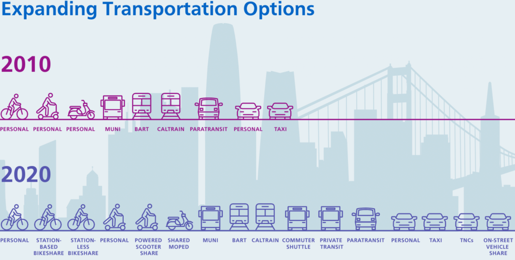
Performing a more complex analysis, the San Francisco Municipal Transportation Agency (SFMTA) analysed the city to better understand the use of roads and kerbsides. SFMTA estimates that the current allocation of kerb space (the space between the roadway and the sidewalk) is skewed towards private car parking (90%), with only 2% dedicated to logistics and access for goods, and only 1% to be used by people and public services. This happens despite a significant diversification of the transportation options. Practically, the outdoors is hosting a variety of mobility uses, yet most roads and kerbsides are still designed for private cars.
4. Different land uses, different users, different requirements
One reason for this lack of adaption comes from the complex relationship between outdoor activities and land use. One of the few empirical studies researching the relationship between land use and kerbside activities focused on two high streets in London. The results show that certain types of businesses, such as supermarkets and take away shops, are related to the number and duration of parking and loading activities. Floor area also influences kerbside use. The number of parking activities, the duration of parking activities for some businesses, and the duration of loading activities tends to increase with floor area (although the increase is progressively smaller). The number of loading activities does not show the same tendency, which might be partly explained by bigger loading vehicles used at bigger premises, resulting in more consolidation. Illegal loading is frequent, often caused by other illegally parked cars occupying the loading bays (Chan et al., 2020).
Thus, different users have different needs from the same location. For instance, compared to passenger vehicles, freight vehicles require larger parking spaces both because of the bigger vehicle size, and because of the need to access the cargo for loading and unloading goods (Alho et al., 2022). As previously discussed, even within the logistics sector, there is significant heterogeneity in terms of vehicle types, sizes, and dwell times. An extreme comparison can be made between a bike food deliverer that will only require a couple of minutes and 2 square metres, compared to a service provider that might need more than an hour and about 10 square metres for their parked van.
Besides parking for private and logistics activities, streets and outdoor spaces must currently meet much more diverse expectations: from mobility to public seating, terraces, and leisure spaces.
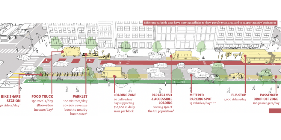
Different kerbside uses have varying abilities to draw people to an area and to support local businesses. (NACTO, 2017)
5. Fluctuating pressure on outdoor space
The pressure on urban space is not evenly distributed across urban spaces and/or periods of the day. In fact, a significant amount of outdoor urban space is idling at times. For instance, roads which are congested during rush hour might be empty during night-time, while parking in residential areas is occupied during the night, but might be empty during working hours. As streets and kerbs fulfil varying roles and can support different uses, they would also benefit from flexible or more dynamic regulatory patterns [SR1]. Examples of dynamic space management include time windows for different activities (e.g., kerb spaces that allow loading/unloading activities during the day, and terraces during the evening) or varying amounts of space dedicated to specific transport modes (e.g., opening more lanes in a direction only for buses, taxis, and bikes during rush hour). Optimistic outlooks were predicting four years ago that ‘with new technologies, new rules and new use cases, kerbs are no longer static, inflexible installations. Instead, kerb use will resemble dynamic, highly flexible, self-solving puzzles’ (ITF, 2018, p. 10). Although, in theory, dynamic space allocation could be a viable solution to reduce pressure on outdoor urban space, it has proven difficult to manage so far.
6. Lack of a digital inventory of outdoor spaces
Unfortunately, many local authorities do not have a digital inventory of their public spaces and kerbsides, and the regulations that determine their use. For instance, a suburban neighbourhood might not have any parking regulations, whereas a commercial inner-city street could have certain time windows restricting access. This lack of digitalised overview limits the cities’ understanding of the supply and demand of their assets, as well as their capacity to improve space management. Similarly, different types of land use will have specific access and parking requirements, making it difficult for logistics operators to comply with rules. The uncertainty and lack of standardised regulations lead many companies to support double parking and pay fines, if they can reduce the cruising time.
7. Conflicting interests and misaligned incentives
Traditionally, zoning separates functions for a reason: to ensure that incompatible activities do not interfere with each other, keeping inner cities safe and clean without encumbering economic activities. As seen thus far, this clear separation is no longer feasible (or desirable), and the conflicts between wider city goals (sustainability, liveability, etc.) and UFT’s goals (accessibility, economic activity), are intensifying. Nonetheless, it is essential to understand that the UFT sector is highly dependent on end customers. If people expect flash deliveries, or retailers only accept deliveries within specific time intervals, logistics providers will adapt to these requirements. Therefore, any access and land use restrictions require the involvement of all these different types of stakeholders. Policy makers must also seek to understand internal company incentives. For instance, drivers will park as close as possible to the delivery location to save time and due to potentially heavy loads (Alho et al., 2022).
Trends, Innovations and Solutions
Within outdoor space management, two main trends emerge: stricter vehicle access regulations and more space for non-motorised travel, as well as dynamic and digitalised space management. These trends are non-exclusive and provide different solution pathways to the increasing need of UFT for public space.
Stricter vehicle access regulations
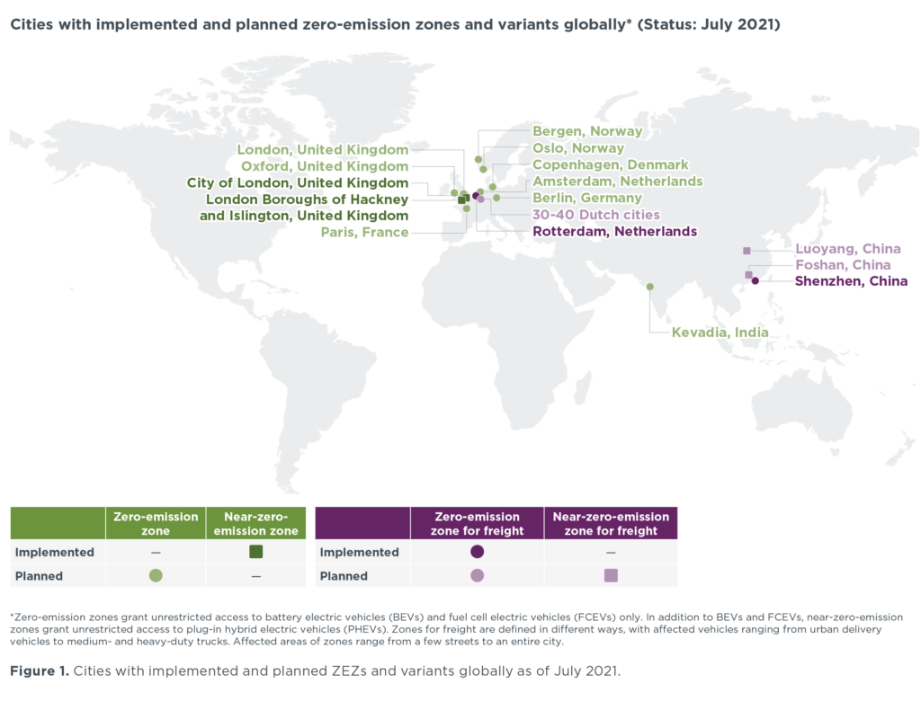
Many cities are devising, piloting, and implementing stricter access rules for polluting vehicles through Urban Access Vehicle Regulations (UVARs). These encompass Low Emissions Zones (LEZ), Zero Emission Zones (ZEZ) and ZEZ-f, which focus specifically on freight. UVARs can be implemented in various ways. Aspects such as the coverage area, criteria applied to the entering vehicles, enforcement measures or charging measures differ widely across European cities (van den Bossche et al., 2017). Some of the most common elements guiding permission to entry are access time (e.g., lorries might only be allowed during specific time windows), vehicle characteristics (tonnage, dimensions, age, Euro emission category), load factors, and access charges (van den Bossche et al., 2017).
A complex policy design is thus required from city planners, who need to weigh the trade-offs between accessibility for logistics operations and reducing congestion and carbon emissions (ULaaDS, 2022) . The Netherlands is among the most advanced countries in this area, showing the largest uptake of ZEZ pilots. The approach is based on multi-stakeholder collaborations with logistics operator associations and municipalities alike. The country has set the goal to introduce zero-emission areas for urban logistics in 30 to 40 big cities by 2025 (Ploos van Amstel, 2020).
Implications of ZEZ for logistics operators
Strict ZEZ’s translate into new conditions for logistics operators, which are further complicated by challenging customer demands (e.g., flash deliveries). This requires a new approach for logistics operators as the electrification and dispersed demand requires evolving logistic models and fleets. As delineated in the previous URBANIZED observatory article, fleet diversification comes with challenges in financing, route planning, organization of hubs and consolidation, charging infrastructure and staffing. On top of that, an additional challenge for logistics operators is the wide variety of UVARs implemented, and the lack of standardised approaches, calling for a resolute response from policymakers. The URBANIZED H2020 project aims to support logistics operators in the transition towards zero emissions deliveries, especially in restricted urban zones such as low and zero emissions zones. Combined, the aforementioned trends call for additional and flexible trips, to be executed by compact e-vehicles with smaller load capacity. The projected electric N1 e-vehicle (<3.5 tonnes) is smaller, safer, energy-efficient and has a modular cargo body that can act as a consolidation container at urban freight collection points. This last feature is expected to be a game-changer for logistics operators who require flexibility in vehicle-restricted urban environments. Namely, the modular cargo body and electrical hand-truck allows operators to quickly swap cargo-bodies whilst the vehicle is at the logistics hub, and easily carry out loading-unloading whilst the vehicle is underway.
Dynamic allocation of urban space
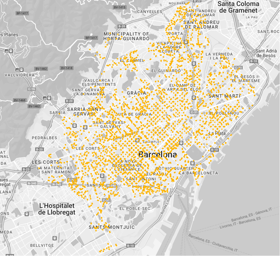
Although reallocation of outdoor space to more citizen-friendly purposes (e.g., cycling lanes, parklets or temporary markets) is not new, seeing road space as a dynamic asset is still underway (Valença et al., 2021). So far, dynamic kerb management is the main spearhead of dynamic space allocation with regards to urban logistics. Some cities experimenting with it include Barcelona, London, and San Francisco.As one of the first European cities, Barcelona implemented a city-wide dynamic kerbside management system in 2015. Logistics drivers need to register online to park in one of the over 9000 loading and unloading areas that the local authority offers for free (see map of DUM spaces above).
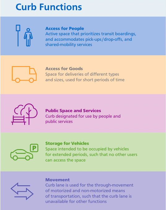
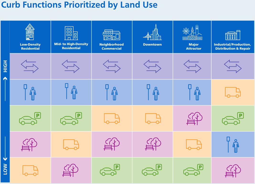
Together with the rising popularity of the smart city concept, London and San Francisco also picked up on the idea in their urban logistic strategies released in the last two years. Moreover, both emphasise the use of loading/unloading areas for other purposes during off-peak moments, depending on the needs of different urban neighbourhoods. The San Francisco Municipal Transportation Agency (SFMTA) developed an approach to manage the city’s limited kerb space, considering five main functions that kerbs can fulfil. Depending on the type of area and land use, these functions are given different degrees of priority.
Digitalised inventory of urban space and enforcement
An important prerequisite of effective dynamic urban space management is the digitalisation of available space. Related to cities’ dynamic kerbside management, this entails creating a digital inventory of available public kerbside space and its real-time usage. To gather raw data, small parking nodes, license plate recognition and camera footage is often used. The latter is subsequently processed by deep-learning algorithms to identify vehicles and subsequently spot occupancy (otherwise called computer vision) (VADE, n.d.). Computer vision is also regarded as the most cost-effective and flexible among the data gathering solutions, which explains its widespread attention in academia and research (de Almeida et al., 2022). A subsequent challenge for cities is processing the data into actual insights, which requires expertise that is often not found within municipalities. Although some cities have shown to process kerbside data themselves, the majority of interested cities rely on external data solution providers (VADE, n.d.).
Going one step further, enforcement of any space management approach is key. This can be done physically, electronically, or virtually (geofencing). Without it, local authorities fail to provide a level playing field, potentially creating negative impacts for those stakeholders willing to abide by rules (POLIS, 2021).
Conclusion
With the shifting demands towards same-day-delivery and e-commerce, citizens and business alike have spurred an increase of urban logistics activity, and thereby the amount of space required. In most cities, public space is under mounting pressure to accommodate a variety of needs. Here, the classic chasm between city and logistics operators’ interests makes for a complex decision-making environment. Surfacing trends and solutions among cities include Urban Access Vehicle Regulations, time windows, as well as dynamic and digital kerbside management.In the end, the transition to more liveable, yet accessible cities will require the collaboration and engagement of both the private and the public sector, and a close follow-up to understand the impact of policy changes and actions.
In the second part of this series, we will be looking at the interaction of urban freight transport and indoor space, to see how logistics sprawl is matched by a concurrent phenomenon of relocation of logistics within inner cities.
Acknowledgements
We would like to thank the following persons for their contributions to the article:
- Josep Maria Salanova from the Centre for Research and Technology, Thessaloniki, Greece
- Marij Lambert from the City of Leuven, Belgium
- Veerle De Meyer from the City of Mechelen, Belgium
Bibliography
Ajuntament de Barcelona. (2015). Pla de Mobilitat Urbana de Barcelona.
Alho, A., Oh, S., Seshadri, R., Dalla Chiara, G., Chong, W. H., Sakai, T., Cheah, L., & Ben-Akiva, M. (2022). An agent-based simulation assessment of freight parking demand management strategies for large urban freight generators. Research in Transportation Business & Management, 43, 100804. https://doi.org/10.1016/J.RTBM.2022.100804
Chan, M., Jones, P., & Anciaes, P. (2020). Managing kerb conflicts: Relationships between kerbside activities and land uses. Proceedings of the 18th Annual Transport Practitioners’ Meeting 2020, Transport.
Davani, A. (2020). Delivery vehicles are a necessary target to patch city revenues . Smart Cities Dive. https://www.smartcitiesdive.com/news/delivery-vehicles-are-a-necessary-target-to-patch-city-revenues/585349/
de Almeida, P. R. L., Alves, J. H., Parpinelli, R. S., & Barddal, J. P. (2022). A Systematic Review on Computer Vision-Based Parking Lot Management Applied on Public Datasets. https://doi.org/10.1016/j.eswa.2022.116731
Generalitat de Catalunya. (2021). Dades bàsiques municipals i comarcals Barcelonès. Mapa urbanístic de Catalunya.
International Council on Clean Transportation. (2021). A global overview of zero-emission zones in cities and their development progress –. https://theicct.org/publication/a-global-overview-of-zero-emission-zones-in-cities-and-their-development-progress/
ITF. (2018). The Shared-Use City: Managing the Curb. 10–13.
Local Government Association. (2022). The future of last-mile deliveries: Understanding the local perspective.
NACTO. (2017). Curbside management strategies for improving transit reliability curb appeal.
Ploos van Amstel, W. (2020). Zero-emission zones in the Netherlands: 2025, 2027 and later? http://www.citylogistics.info/policies/zere-emission-zones-in-the-netherlands-2025-2027-and-later/
POLIS, A.-E. &. (2021). Cities-Regions and Companies working together. Guide for advancing towards zero-emission (Issue December).
Schaefer, M. (2021). The State of Curb Management in 2021. VADE. https://www.vade.ai/post/the-state-of-curb-management-in-2021
SFMTA. (2020). Curb Management Strategy. San Francisco Municipal Transportation Agency .
ULaaDS. (2022). Low Emission Zones and Urban Logistics: How can we make it work? https://ulaads.eu/low-emission-zones-and-urban-logistics-how-can-we-make-it-work/
VADE. (n.d.). The State of Curb Management in 2021. Retrieved June 10, 2022, from https://www.vade.ai/post/the-state-of-curb-management-in-2021
Valença, G., Moura, F., & Morais de Sá, A. (2021). Main challenges and opportunities to dynamic road space allocation: From static to dynamic urban designs. Journal of Urban Mobility, 1, 100008. https://doi.org/10.1016/j.urbmob.2021.100008
van den Bossche, M., J., Maes., Vanelslander, T., Macário, R., & Reis, V. (2017). Treatment of logistics activities in Urban Vehicle Access Regulation Schemes.
World Economic Forum. (2020). The Future of the Last-Mile Ecosystem.Transition Roadmaps for Public-and Private-Sector Players. www.weforum.org